
Streatham housing statistics 2026
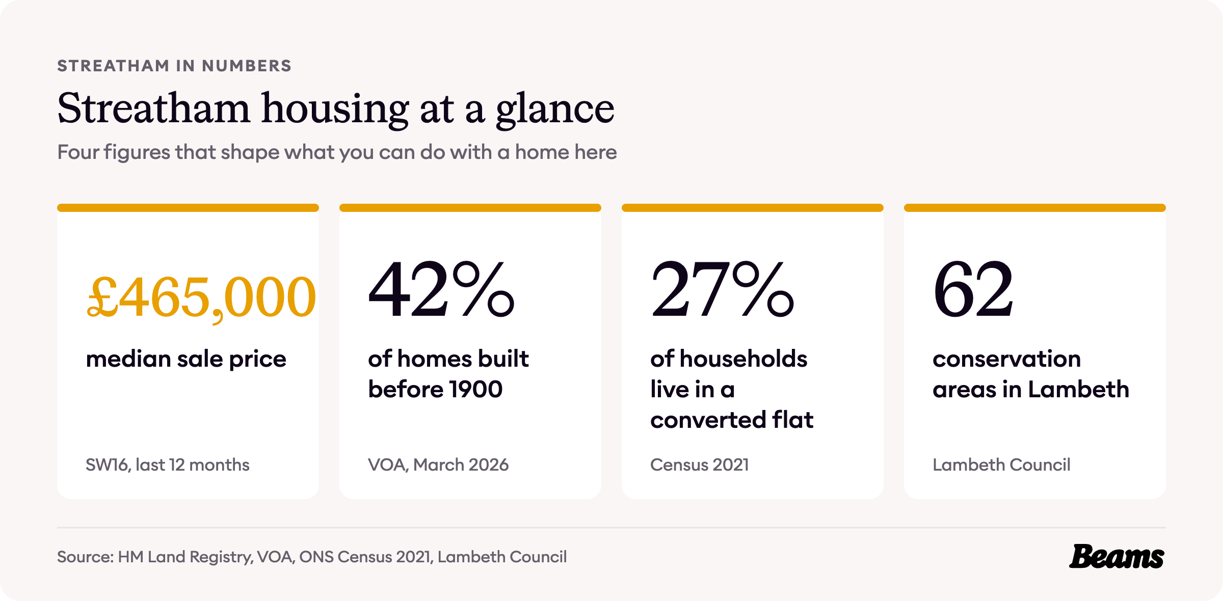
Much of Streatham was built as a run of planned estates between the 1870s and the 1920s, and many of its big houses have since been split into flats. More than a quarter of households now live in a converted flat, and the typical SW16 home sold for £465,000 in the year to September 2026.
All the figures below are official and dated, so you know the ground before you plan a home renovation in Streatham. Each source is numbered in brackets and listed at the end.
How Streatham was built
Streatham grew estate by estate. Telford Park was laid out between 1878 and 1882 by the architect E J Tarver, who made sure that no two of its Queen Anne-style houses were identical. Its lawn tennis club opened in 1880 [1]. On the Streatham Park Estate, suburban building began in the 1880s and carried on into the interwar years [2].
The Leigham Court Estate was developed by the Artizans, Labourers and General Dwellings Company between 1889 and 1928, an early model housing estate of long terraces of purpose-built flats and houses on a grid [3]. Along Streatham High Road the buildings are mostly late nineteenth century, while much of Streatham Hill, with its mansion blocks, dates from the early to mid twentieth century [4].
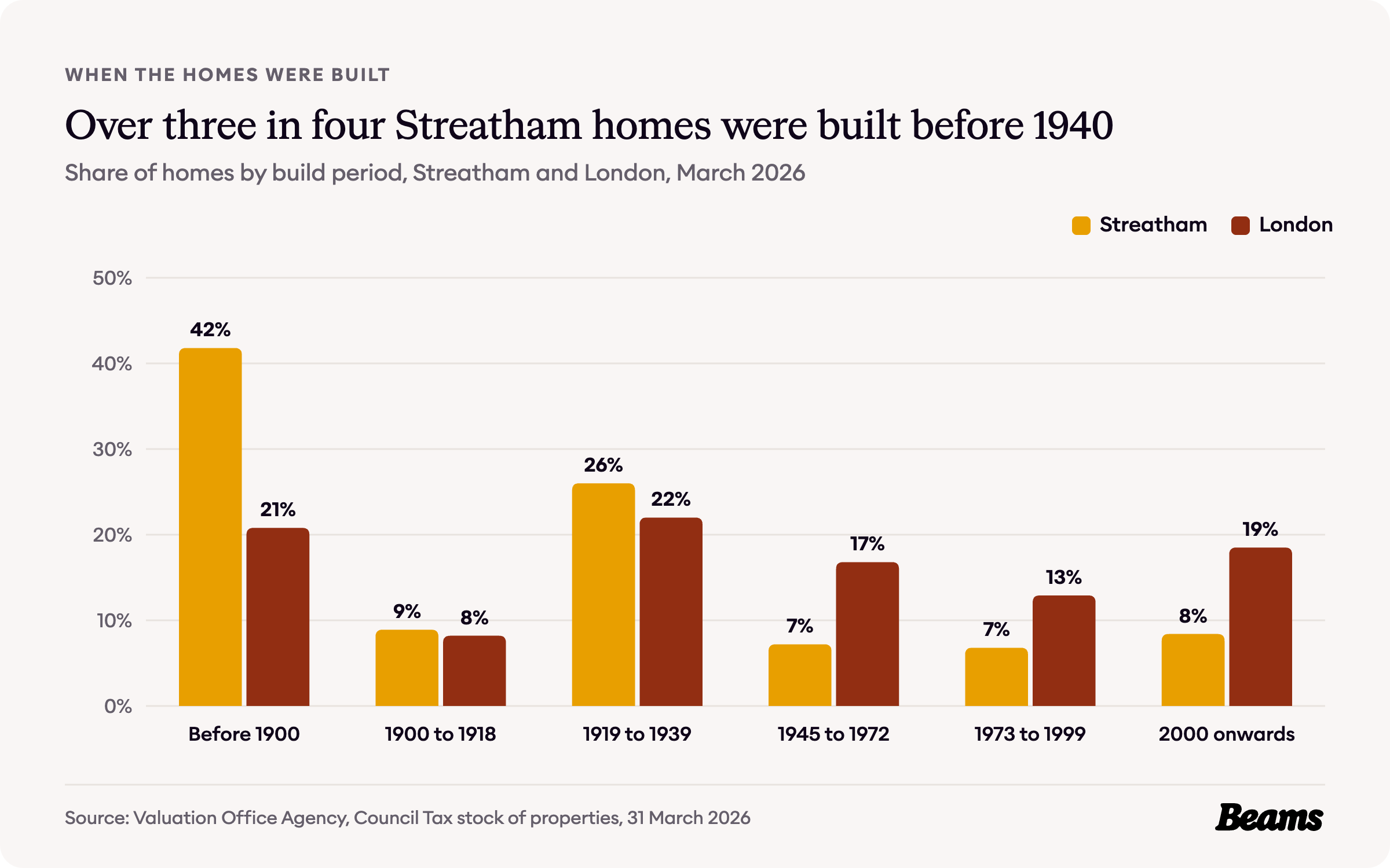
The Valuation Office Agency counts 19,980 homes in Streatham's five census areas. 41.8% were built before 1900, twice London's 20.8%, and 26.0% between the wars, against 22.0% for London. Add the 8.9% built from 1900 to 1918 and 76.7% of Streatham's homes date from before 1940, against 51.0% across London [5].
Only 8.4% have been built since 2000, less than half London's 18.5% [5]. That leaves a neighbourhood of Victorian terraces and interwar houses, most with a pitched roof and space under it, which makes a loft conversion in Streatham the natural next step for a household that needs another bedroom.
How Streatham households live
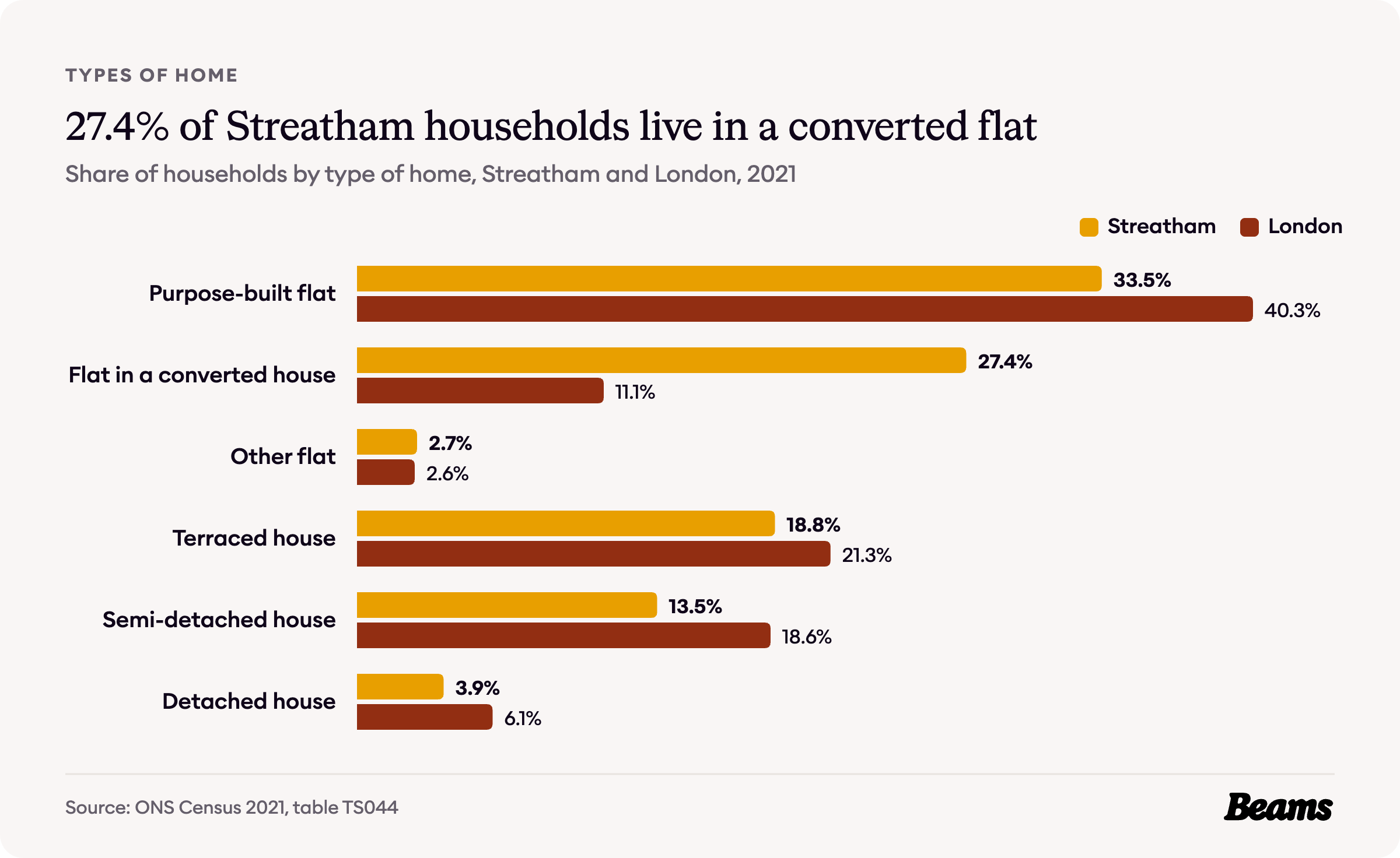
Streatham's large houses have been divided up more than most. The 2021 Census found 27.4% of households living in a flat inside a converted house, against 20.6% across Lambeth and 11.1% across London [6].
Another 33.5% live in a purpose-built flat, so 63.6% of households live in a flat of some kind, against 54.0% for London. 18.8% live in a terraced house, 13.5% in a semi-detached house and 3.9% in a detached house [6]. In a flat carved out of a house, the kitchen often sits wherever the conversion could fit it, so a kitchen renovation in Streatham is usually as much about layout as new units.
Who owns Streatham's homes
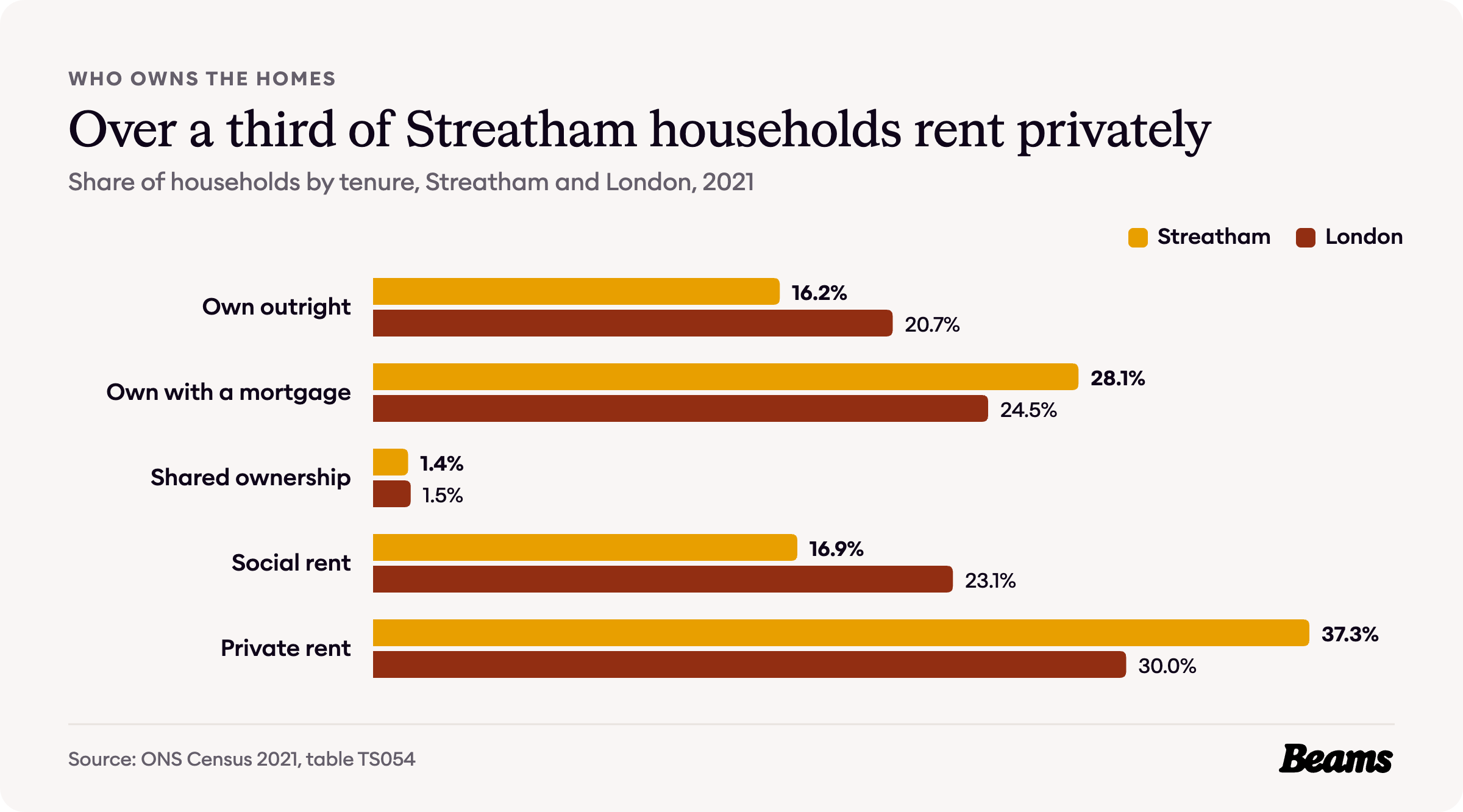
Streatham sits close to the London average on ownership. 44.3% of households own their home, 16.2% outright and 28.1% with a mortgage, against 45.2% across London and 33.0% across Lambeth [7].
Private renting is the largest single tenure, at 37.3% of households against 30.0% for London. Social renting is less common than in the rest of the borough, at 16.9% against 33.6% for Lambeth and 23.1% for London [7].
What a Streatham home costs
First, where the figures come from. The UK House Price Index and the rent figures cover the whole London Borough of Lambeth. The census and VOA figures on this page cover Streatham's five census areas: Streatham Hill, Streatham Central, Streatham Green, Streatham Common and Streatham Vale. The local sale prices cover the SW16 postcode district.
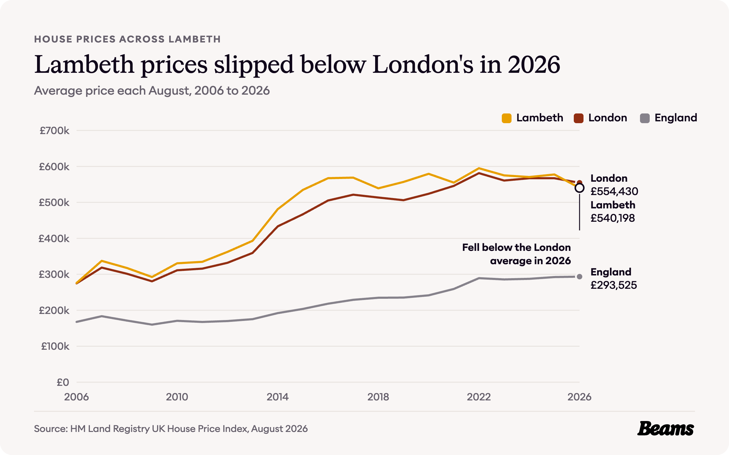
Across Lambeth, the average home cost £540,198 in August 2026, 6.5% less than a year earlier [8]. That took the borough just below the London average of £554,430 for the first time in the twenty Augusts since 2006, when Lambeth's average was £275,726. Both are well above the England average of £293,525 [9].
What actually sells in SW16
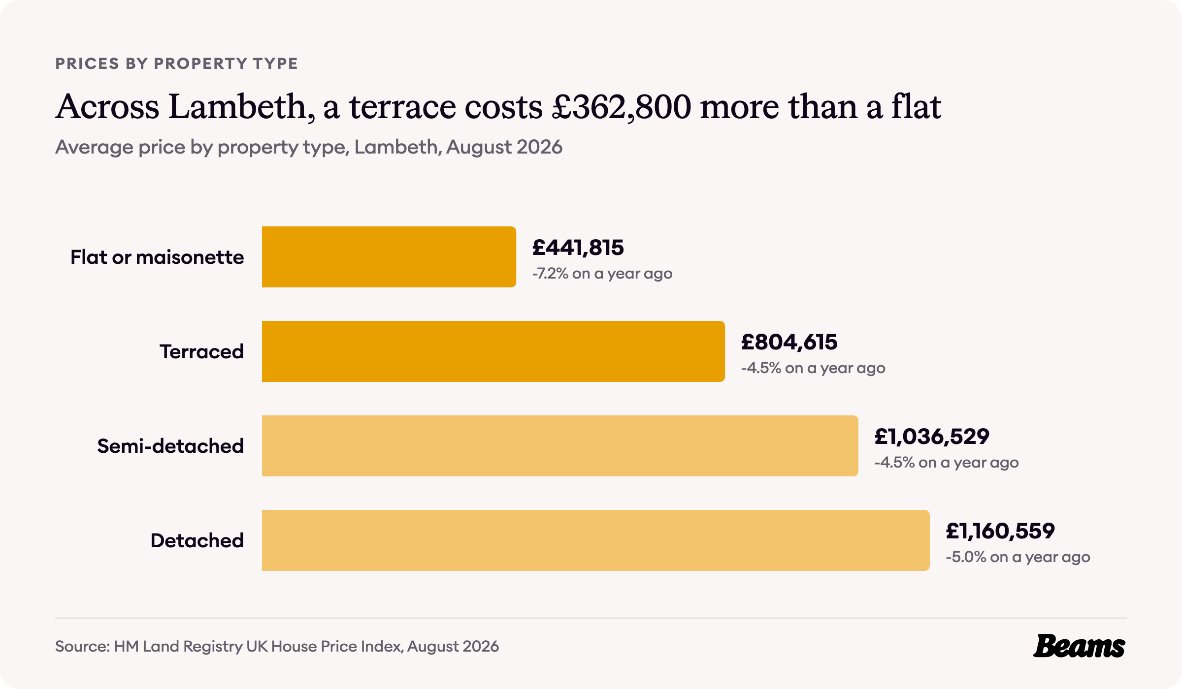
Across Lambeth, a flat or maisonette averaged £441,815 in August 2026 and a terraced house £804,615, a gap of £362,800 [8]. Streatham comes in well below those borough figures.
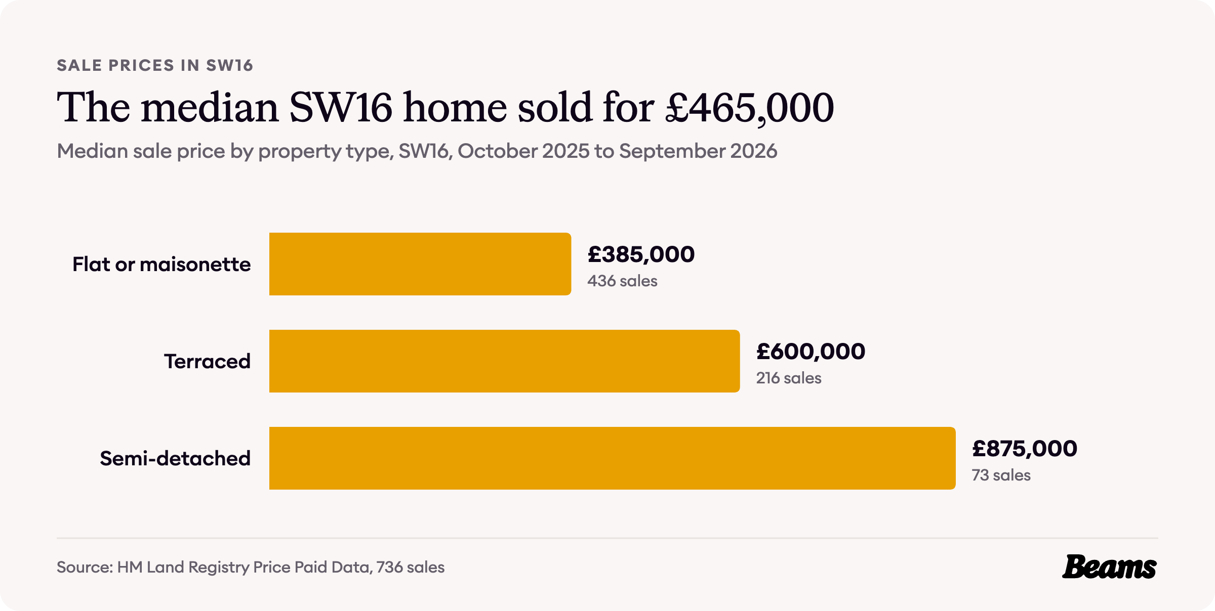
HM Land Registry recorded 736 sales in SW16 between October 2025 and September 2026, at a median price of £465,000. The median flat sold for £385,000, the median terraced house for £600,000 and the median semi-detached house for £875,000. Flats made up 436 of the 736 sales [10].
Across Lambeth, first-time buyers paid an average of £474,320 and home movers £682,063 [8]. In SW16 the step from a terrace to a semi costs £275,000 at the median, so for a family in a Streatham terrace a house extension in Streatham adds room without paying for that next step.
What it costs to rent in Streatham
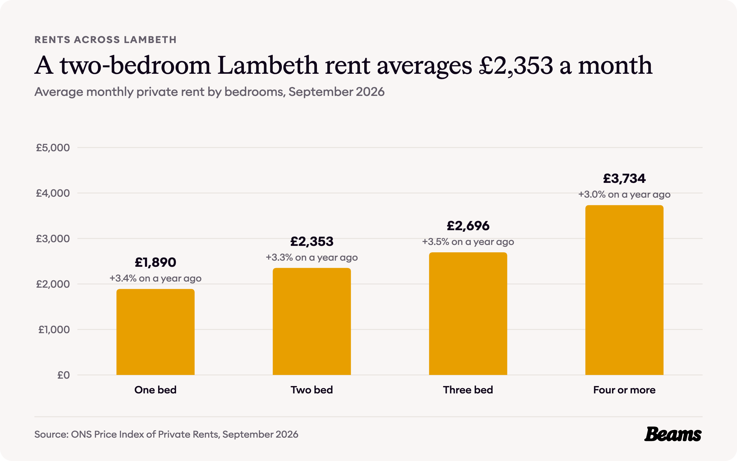
Rents are only published for the whole borough. The average private rent across Lambeth was £2,538 a month in September 2026, up 3.4% on a year earlier. A two-bedroom home averaged £2,353 a month and a three-bedroom home £2,696 [8].
Those figures matter more in Streatham than in most of Lambeth, because 37.3% of its households rent privately [7]. With so many converted flats in the rental market, landlords often refit between tenancies, and a bathroom renovation in Streatham is usually the first job on the list.
Council Tax bands in Streatham
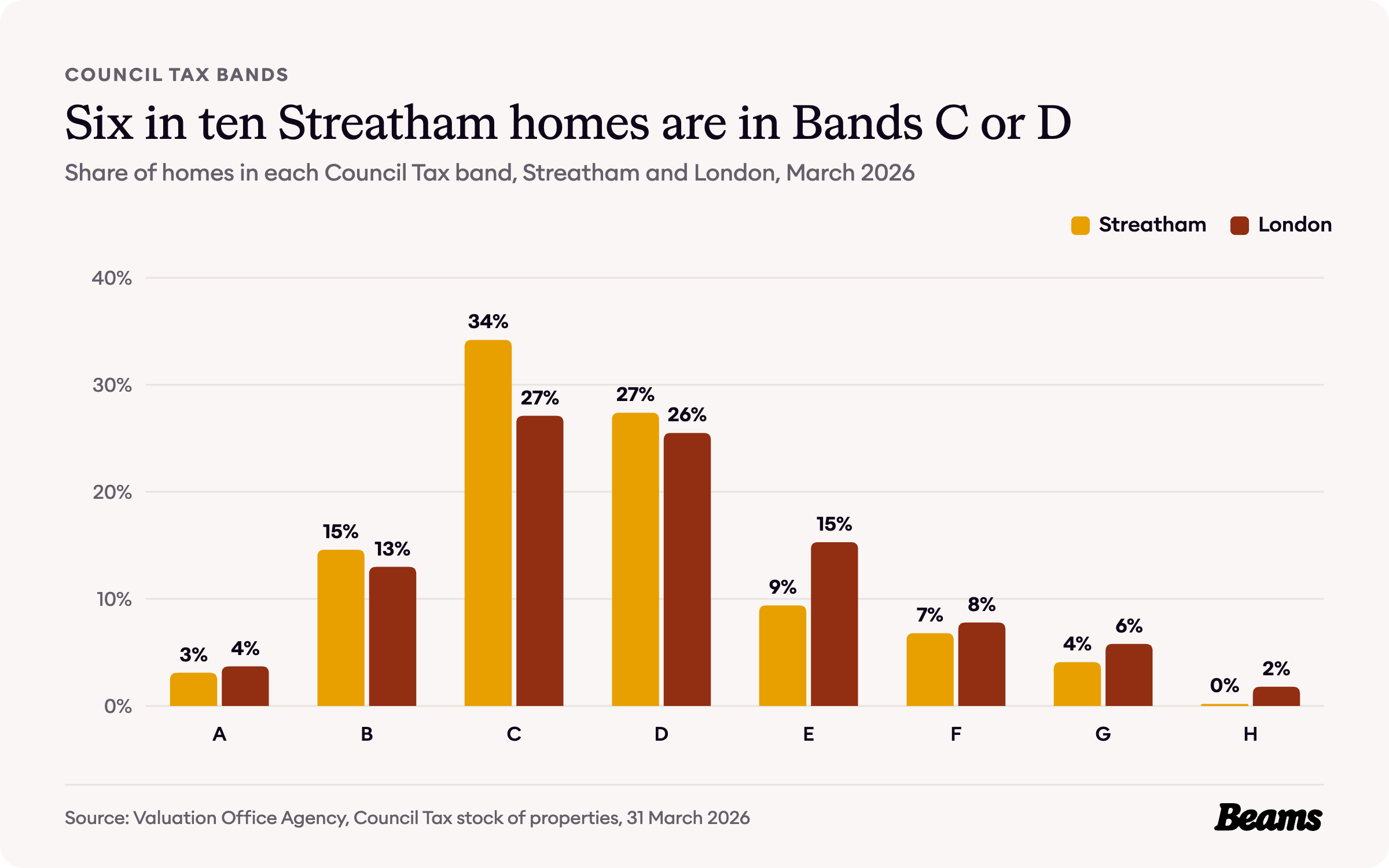
Streatham's homes cluster in the middle bands. 34.2% are in Band C and 27.4% in Band D, 61.6% together, against 52.6% across London [5].
The top bands are thin: 11.1% of homes are in Bands F, G or H, against 15.4% for London, and just 0.2% are in Band H [5]. Many middle-band homes here are flats in converted houses, and GOV.UK notes that turning flats back into a single house is one of the changes that can move a property into a different band [11].
The rules on your street
Lambeth has 62 conservation areas, covering about 30% of the borough. Four carry Streatham's name: Streatham Common, Streatham High Road and Streatham Hill, Streatham Lodge, and Streatham Park and Garrads Road. The Leigham Court Estate and Telford Park are conservation areas too [12].
Two of them have Article 4 Directions. The Leigham Court Estate has one, with its notice dating from 1996 [3]. At Streatham Lodge, a direction covering part of the area was served on 23 July 2010 and confirmed on 18 October 2010 [13]. Where a direction applies, planning permission is needed for the works it lists [14]. Digging down is one of the bigger changes a house can see, so a basement conversion in Streatham starts with a check of the address.
If you do need permission, the national time limit applies: a council should decide a valid application for anything short of major development within eight weeks, unless you agree a longer period in writing [15]. Because the rules can change from one Streatham street to the next, our builders in Streatham and planners check what applies to your address before any work begins.
Streatham housing statistics at a glance
- Median sale price, SW16, October 2025 to September 2026: £465,000 [10]
- Median flat, SW16: £385,000 [10]
- Median terraced house, SW16: £600,000 [10]
- Average house price, Lambeth, August 2026: £540,198 (London £554,430) [8] [9]
- Average private rent, Lambeth, September 2026: £2,538 a month [8]
- Homes built before 1900: 41.8% (London 20.8%) [5]
- Households in a flat in a converted house: 27.4% (London 11.1%) [6]
- Households renting privately: 37.3% (London 30.0%) [7]
- Homes in Council Tax Bands C or D: 61.6% (London 52.6%) [5]
- Conservation areas in Lambeth: 62, four named after Streatham [12]
Frequently asked questions
References
- Lambeth Council, Telford Park conservation area (CA44). Conservation area profile. Accessed 29 October 2026.
- Lambeth Council, Streatham Park and Garrads Road conservation area (CA12). Conservation area profile. Accessed 29 October 2026.
- Lambeth Council, Leigham Court Estate conservation area (CA31). Conservation area profile and Article 4 Direction. Accessed 29 October 2026.
- Lambeth Council, Streatham High Road and Streatham Hill conservation area (CA54). Conservation area profile. Accessed 29 October 2026.
- Valuation Office Agency, Council Tax: stock of properties 2026. Tables CTSOP4.1 and CTSOP1.1, properties by build period and by Council Tax band at 31 March 2026, Streatham's five census areas and London.
- ONS, Census 2021 table TS044: Accommodation type. Households by type of home, Streatham's five census areas, Lambeth and London.
- ONS, Census 2021 table TS054: Tenure. Households by tenure, Streatham's five census areas, Lambeth and London.
- ONS, Housing prices in Lambeth. UK House Price Index for August 2026 and Price Index of Private Rents for September 2026, published 21 October 2026.
- HM Land Registry, UK House Price Index. Average prices for Lambeth, London and England, August 2006 to August 2026.
- HM Land Registry, Price Paid Data. Sales in the SW16 postcode district, October 2025 to September 2026.
- GOV.UK, How Council Tax works: working out your Council Tax. Changes that can move a property into a different band.
- Lambeth Council, Conservation area profiles. Number, coverage and names of Lambeth's conservation areas. Accessed 29 October 2026.
- Lambeth Council, Streatham Lodge conservation area (CA62). Conservation area profile and 2010 Article 4 Direction. Accessed 29 October 2026.
- Lambeth Council, Article 4 Directions. Conservation areas with Article 4 Directions. Accessed 29 October 2026.
- GOV.UK, Determining a planning application. Planning practice guidance on statutory time limits, paragraph 001.
Thinking of improving rather than moving?
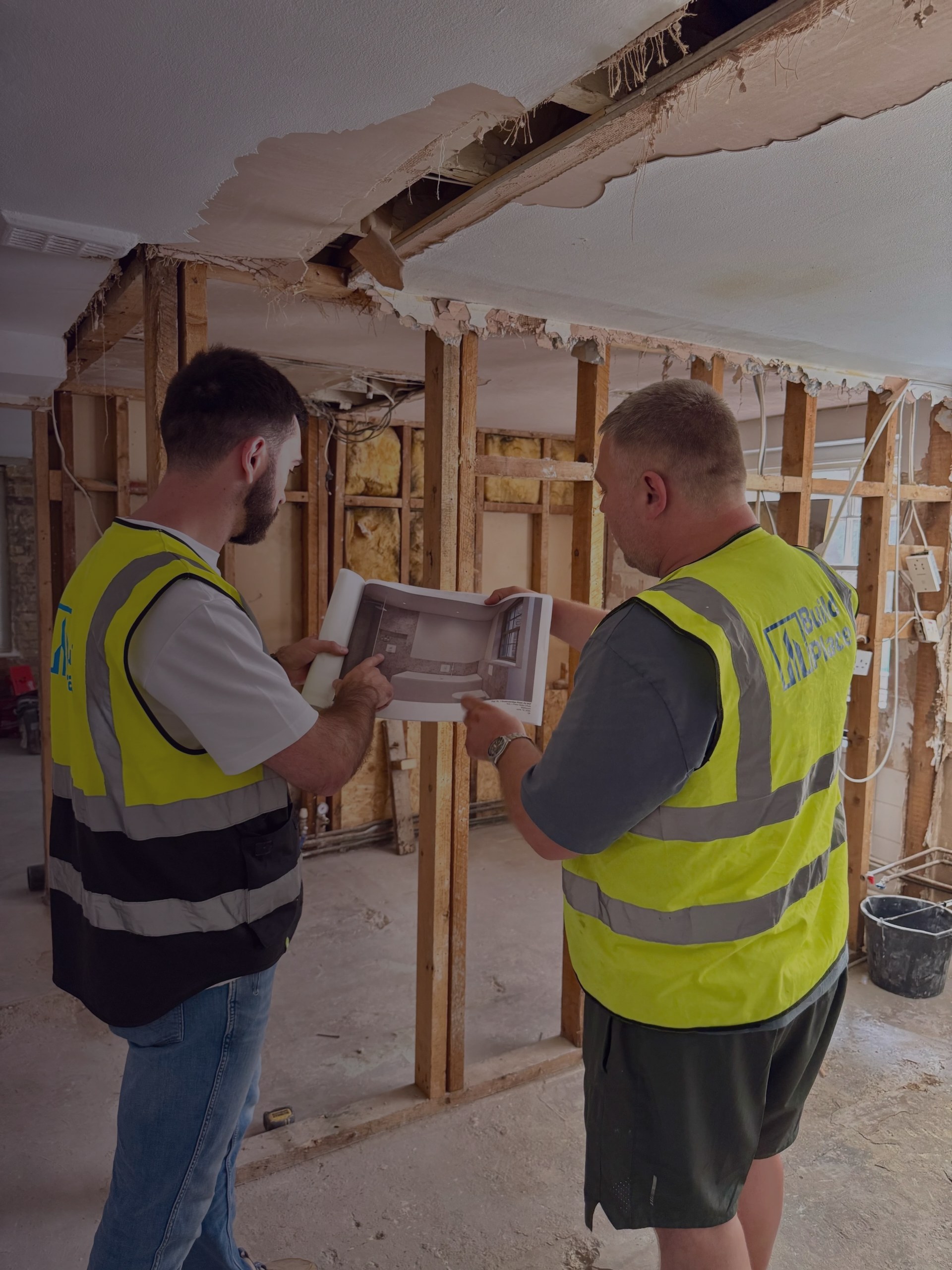
Tell us about your Streatham home and what you want to change. We'll give you a free estimate, then up to three vetted builders quote against the same specification.